
Escalante, Utah: Rock Formations, Pizza, and Sandy Trails
- Oct 25, 2025
- 6 min read
Updated: Nov 4, 2025
October 2024

Welcome back to our adventure! If you missed Part 1, we started out in Page, Arizona. We camped at Lake Powell, rented a pontoon boat, and watched our dogs, Shilo and Maise, have completely opposite reactions to the water. One splashed like a pro, while the other acted like the lake didn’t exist!
Now, in Part 2, we’re heading deeper into Utah—to Escalante. The landscapes were just as surprising, and the food? Well, let’s just say we’re still dreaming about that pizza.
Canyons of Escalante RV Park: A Tight Squeeze
After leaving Page, we made our way into Utah and stayed three nights at Canyons of Escalante RV Park. The park was nice overall, but I will say the RV spots were really narrow. Our neighbors had slide-outs on both sides of their motorhome and didn’t even have room to put out chairs. Luckily, we only have one slide on the driver’s side, so we enjoyed the crisp mornings and cool evenings outside.


Tip: Book a corner spot if you can—extra breathing room makes all the difference.
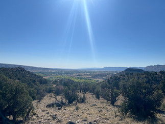
Devils Garden: A Dirt Road Worth It
On our first full day, we decided to check out Devils Garden. This meant driving 12 miles on a bumpy, dusty dirt road. It was long but worth it once we arrived. The formations were incredible! Hoodoos, arches, and giant rock shapes were everywhere. It almost felt like being on another planet.
A little background: Devils Garden is part of the Grand Staircase–Escalante National Monument. This protected area spans over a million acres filled with slot canyons, arches, cliffs, and natural bridges. This little pocket is one of the most family-friendly spots in the monument. Unlike other hikes that require long treks, Devils Garden lets you park and walk right into a playground of bizarre rock formations.
The sandstone here is part of the Entrada Sandstone formation, deposited nearly 160 million years ago when this region was a vast desert. Over millions of years, wind and water sculpted the rock into whimsical shapes—everything from balancing rocks and natural arches to mushroom-shaped hoodoos.
Fun fact: Locals and travelers alike often call Devils Garden “Utah’s Dr. Seuss playground” because the formations look like they came straight out of his sketchbook. Twisting shapes, stacked rocks, and odd angles make it feel like you’ve stepped into a storybook.
One important thing to know about this road is that you definitely don’t want to get stuck out there on a rainy day. With that much dirt, it would turn into a mud trap real quick. But since the weather was good, we had no trouble getting out there and enjoyed exploring all the unique rock shapes.


Trail Tip: Don’t go if rain is in the forecast. That road turns into a mudslide trap faster than you can say, “Where’d the traction go?”
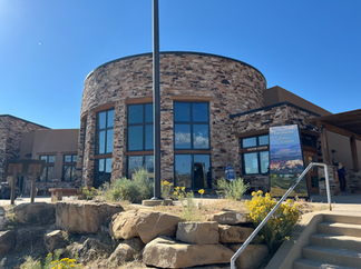
Pizza at Escalante Outfitters
After that hike, we were hungry, so we headed to Escalante Outfitters. It’s part store, part restaurant, and a real local hangout spot. Seating inside and outside was very limited, and it was packed, but we managed to find a table. The pizza was delicious—honestly, some of the best we’ve had.
Even better, they allow dogs outside, so we brought Shilo and Maise with us. Shilo surprised us by eating some of our tomatoes from our salad, while Maise turned her nose up—she’s strictly a meat-only kind of dog. The weather was perfect too: cloudy, with a cool breeze that made sitting outside so nice.


Escalante Petrified Forest: Not Quite What We Expected
The next day, we went to Escalante Petrified Forest State Park to try out the 2-mile loop hike. The trail was steep but offered beautiful views of the surrounding landscape. The only downside was we expected to see a lot more petrified wood. Instead, we only spotted a few scattered pieces along the way.
A little background: This park protects a large deposit of petrified wood that’s around 135 to 155 million years old, dating back to the Jurassic period. At that time, this whole area was a lush lowland with rivers and floodplains. Giant conifer trees grew here, and when they fell, they were buried by sediment. Over millions of years, minerals seeped into the wood, replacing the organic material and turning the logs into colorful stone. Today, many of the pieces have rich red, yellow, and purple hues thanks to the iron and manganese in the rock. Some of the petrified logs here stretch over 50 feet long, which is wild to imagine when you’re walking through the desert.
Fun fact: Escalante’s site is much smaller and less famous than the Petrified Forest National Park near Holbrook, Arizona. That park is home to one of the largest and most colorful petrified wood deposits in the world. If you’ve been there, this park feels more low-key and less crowded. While you won’t see fields of petrified logs, you do get sweeping views of Utah’s red rock country along the trail.
The park also has a reservoir, Wide Hollow, which makes it a popular spot for boating, fishing, and camping. So even if the petrified wood isn’t what you came for, there’s plenty to do here.
As for us, there were longer trail extensions that supposedly show more of the petrified trees. However, because of the climb and how steep the trail was, my mom wasn’t able to go further. So we stuck to the main loop. We still enjoyed the hike for the views, but if you’re going mostly for the petrified wood, it’s probably best to plan on the longer trails and go early before the sun heats everything up.
Trail Notes:
If you want to see more petrified wood, go early and take the longer trail extensions.
The main loop is short but steep—bring good shoes and plenty of water.
The best time to hike is morning or late afternoon to avoid the heat.
The views are beautiful either way, so it’s worth the climb even if you don’t see much petrified wood.


Note: If you want to see more petrified wood, go early and take the longer trail extensions.
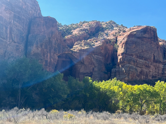
Escalante River to Natural Bridge: Shade, Sand, and Splashing Dogs
After that, we decided to tackle the Escalante River Trail to Natural Bridge, about six miles round trip. The parking lot was tiny, so we ended up parking along the road. We came prepared with a folding chair and packed lunch for my mom since she wasn’t planning on hiking the whole trail. We found her a nice shady spot by the river with the dogs before heading off.
Maise wasted no time—she went straight into the river and, according to my mom, didn’t stop splashing around until we got back. Shilo, on the other hand, stayed busy sniffing everything but had no interest in the water.
The first part of the hike was beautiful, with plenty of shade and little river crossings that only came up to our ankles. But the trail quickly turned sandy, and walking in that much sand felt like trudging on a beach for three miles. Add in the hot sun, and it was a lot harder than we expected.
A little history: The Escalante River was one of the last rivers in the lower 48 states to be officially mapped by the U.S. government, largely because of how rugged and remote the terrain is. It flows through deep canyons, lush riparian zones, and red rock landscapes, eventually joining the Colorado River. The Natural Bridge along this trail is a massive sandstone arch formed by centuries of river erosion. Unlike many arches in Utah that formed from wind carving the rock, this one was created by water slowly cutting away the sandstone until only the bridge remained. It’s one of the highlights of the Grand Staircase–Escalante area.
Thankfully, I had downloaded the trail on the AllTrails app. With the membership, you can use the GPS offline, and it came in handy because it let me know right away when I started wandering off the trail. We used it here and also for the Petrified Forest trail. Definitely worth it.
We eventually reached the natural bridge, snapped our pictures, and on the way back decided we’d had enough of walking in soft sand. Instead, we walked in the river most of the way back. It was cooler, faster, and honestly more fun.
By the time we finished, we were wiped out. Two hikes in one day, even though they were great, wore us out. We didn’t even cook that night—just ate leftovers and went straight to bed.
Trail Notes:
About 6 miles round trip—plan for at least 3 hours with breaks.
Limited parking at the trailhead; roadside parking may be necessary.
The first half is shaded with ankle-deep river crossings.
The second half is sandy, hot, and exposed—feels like walking on a beach.
Natural Bridge is a rewarding payoff, especially if you hike back in the river.


Gear Tip: Bring water shoes! Trust me, your feet will thank you.
Wrap-Up
Escalante ended up being a mix of surprises: unique rock formations, one of the best pizzas we’ve had on a trip, a steep trail with not much petrified wood, and a sandy river hike that gave us more of a workout than expected. But we also had shaded river spots, playful dogs, and views that made the effort worth it.


Family-Friendly Highlights:
Devils Garden is great for all ages—no long hiking, just fun exploring.
Escalante Outfitters pizza is worth the wait.
Natural Bridge hike is beautiful, but plan for sun, sand, and water crossings.
Next up: Green River and Goblin Valley—where the rocks look like mushrooms and Galaxy Quest comes to life. Stay tuned!


Comments